
A study published in the journal Earth-Science Review last year provided a revolutionary global compilation of the boundaries of all active tectonic plates on Earth, separated by “geological provinces,” in Shapefile format files. It is currently hosted on GitHub, and the database is available to the entire geoscientific community.
According to the study, The goal of creating this new tectonic model of the planet was to share accurate spatial models of tectonic plates and geological terrain. Which allows “the analysis and interpretation of a wide range of geological data and the development of physical and structural models of the lithosphere.” Dynamic merging classifies data by attributes such as crust type, plate, province, and orography (most recent event).
On his LinkedIn page, the study’s lead author, Derek Hasterock, of the University of Adelaide, Australia, offers some highlights of the study:
- 90% of Quaternary earthquakes and 80% of volcanoes are explained by the new model.
- 16% of the Earth’s surface lies within the plate boundary zone.
- 57.5% of the Earth’s crust is oceanic in nature, and the rest is continental.
Map models for comparative studies of plate tectonics
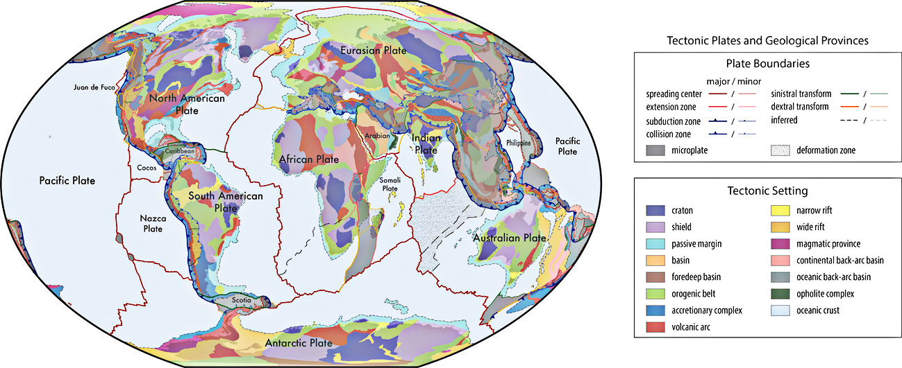 Tectonic plates and geological provinces.source: Hasterok et al.
To understand the complex structural structure of plate tectonics, it is also necessary to evaluate changes in rocks on the Earth’s surface over time. This means knowing the chemical and physical properties of the surrounding lithosphere. To achieve this, the study presented two main models:
- Global geological provinces: These maps, which are spatially accurate, include a consistent set of basic geological features, which are essential for global comparative studies and reliable plate reconstructions.
- Current council limits: This model improves other existing models, by integrating geophysical, geochemical and geochronological characteristics. The goal here, according to the study, is to expand the tectonic boundaries until about 2.3 billion years ago, while adding different interpretations and geological observations.
How important is the new map of Earth’s tectonic plates?
New digital plate models have become a standard for classifying geological data in various databases around the world. Since they are all free and open source, It can be updated and continued improvements are being investigated by the geoscience community. The idea, according to the authors, is to foster an adaptable and interactive environment for a better understanding of our geological history.
In this sense, one of the big news is the move from traditional raster maps (where each pixel represents a cell in the grid), For vector formatting of shape files. In practice, the change allows for a more precise understanding of the Earth’s geological fabric, since in this new configuration, each polygon, line or point can represent separate geographic elements (roads, rivers, boundaries), as well as geological data.
To make sharing easier, the files have also been released in formats compatible with so-called universal mapping tools, which are programs that manage geospatial data, as well as GoogleEarth.
Did you like the content? So, stay tuned for new studies like this one here at TecMundo and take the opportunity to also find out how today’s earthquakes could be echoes of tremors more than 100 years old.

“Web geek. Wannabe thinker. Reader. Freelance travel evangelist. Pop culture aficionado. Certified music scholar.”